Typhoon Kai Tak to enter East Sea tonight


Tropical storm Kai Tak, which has formed off the east coast of the Philippine’s Luzon Island, will move to the northeastern area of the East Sea and may strengthen, the National Hydro-Meteorological Forecasting Center has said.
At 1 am this morning, the typhoon’s center was located at 17.6 north latitude and 123.1 degree east longitude, east of the island, with winds of 63-87 kph and gusts of 88-117 kph.
The storm is moving west-northwest at 15-20 kph and will enter the northeastern area of the East Sea tonight, the center said.
The storm will continue moving at the same speed, and by 7 pm Thursday it will be near the southeast coast of China’s Guangxi province, with winds of 75-102 kph and gusts of 103-132 kph.
At 1 am August 17, the typhoon will lay 150 km east of Hong Kong, with the same wind force.
The typhoon’s circulation will cause rough seas and bring showers and thunderstorm to the impacted area of the East Sea this afternoon, with winds varying between 40 and 75 kph. In the area near the typhoon’s eye, winds will be stronger, at 76-102 kph, together with gusts of 103-132 kph.
The storm, which is combining with a strong southwest monsoon, will also cause rough seas in the middle and southern areas of the East Sea, including the waters around Vietnam’s Truong Sa (Spratly) archipelago, and in the region between Binh Thuan and Ca Mau provinces, with winds of 40- 62 kph and gusts of up to 51- 75 kph.
The Central Steering Committee for Flood and Strom Prevention and Control has asked concerned authorities to keep all boats at sea well informed of the storm’s development so that they can to take safety measures and avoid dangerous areas.
Local authorities and other relevant agencies are required to arrange employees to follow the typhoon closely and send timely reports to the committee.
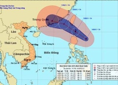 |
| The expected route of Typhoon Kai Tak |
The storm is moving west-northwest at 15-20 kph and will enter the northeastern area of the East Sea tonight, the center said.
The storm will continue moving at the same speed, and by 7 pm Thursday it will be near the southeast coast of China’s Guangxi province, with winds of 75-102 kph and gusts of 103-132 kph.
At 1 am August 17, the typhoon will lay 150 km east of Hong Kong, with the same wind force.
The typhoon’s circulation will cause rough seas and bring showers and thunderstorm to the impacted area of the East Sea this afternoon, with winds varying between 40 and 75 kph. In the area near the typhoon’s eye, winds will be stronger, at 76-102 kph, together with gusts of 103-132 kph.
The storm, which is combining with a strong southwest monsoon, will also cause rough seas in the middle and southern areas of the East Sea, including the waters around Vietnam’s Truong Sa (Spratly) archipelago, and in the region between Binh Thuan and Ca Mau provinces, with winds of 40- 62 kph and gusts of up to 51- 75 kph.
The Central Steering Committee for Flood and Strom Prevention and Control has asked concerned authorities to keep all boats at sea well informed of the storm’s development so that they can to take safety measures and avoid dangerous areas.
Local authorities and other relevant agencies are required to arrange employees to follow the typhoon closely and send timely reports to the committee.
Leave your comment on this story