HCM City maps out plans for water transport expansion


HCM City agencies have unveiled plans to promote waterway transport on the 975km of riverways in the city, according to the city’s Department of Transport.
A number of projects to expand road networks were completed, but did not ease traffic congestion, especially at the northwest gateway and the entry to Cát Lái Port, transport experts said.
Bùi Xuân Cường, director of the Department of Transport, said the city last year built 106km of roads and 21 bridges.
Võ Kim Cương, former deputy architect of HCM City, said that rapid urbanisation was one of the main causes behind the overloaded streets.
The inappropriate locations of ports have also caused pressure to existing road networks.
Cương said the city’s agencies should use the waterways to ease pressure on the city’s roads.
Hà Ngọc Trường, chairman of the HCM City Association of Bridges–Roads–Ports, said the city’s port network has not been fully developed due to the lack of connections between ports and city infrastructure.
Government agencies have focused on the development of land transport while waterway transport received meagre investments, said Trường.
Nguyễn Ngọc Tường, deputy chief of HCM City Traffic Safety Board, said the only way to reduce traffic congestions at roads and entries around ports is to improve waterway transport.
Phạm Sanh, a transportation expert from HCM City, said the waterway network was still not connected to roads, railroads, and the port network.
Morever, the clearance height of most bridges in HCM City is too low while canals are not frequently dredged and have low depth, making them inaccessible for large vessels.
“To develop water transport in HCM City, agencies must build a suitable plan for infrastructure development, especially for waterways connecting HCM City with the Mekong Delta region,” said Sanh.
HCM City agencies said that between 2018 and 2020 the city would mobilise investments from the private sector into water transport infrastructure.
For example, in 2018, upgrades of Bình Lợi Bridge in Bình Thạnh District will be completed, paving the way for waterway transport from Tây Ninh and Bình Dương provinces with ports in HCM City and Cái Mép ports in Bà Rịa – Vũng Tàu Province.
Dredging of canals will help link the Sài Gòn River with the Đồng Nai River.
Canals and rivers on Vàm Cỏ Đông, Chợ Đệm, Bến Lức, Rạch Dơi and Kinh will be dredged, while Ông Nhiêu, Rạch Đĩa and Rạch Dơi bridges will be upgraded to facilitate passenger and cargo transport from HCM City to Long An and Tây Ninh provinces.
Ports and piers along the Sài Gòn River will be moved to suburban areas, while wharves along Đồng Nai, Nhà Bè and Thị Vải rivers will be completed and upgraded.
Trường Thọ ICD (Inland Container Depot) will be relocated and upgraded.
A 6ha river port, to be built in a hi-tech park, will be able to take 1,000 tonne vessels.
City authorities will have plans to add new routes to connect Vàm Cỏ River with ports in Cái Mép – Thị Vải area, and to link Đồng Nai with Thị Vải rivers.
More ICDs will be built to help reduce the pressure on land transport facilities.
To meet the rising demand for passenger transport, the transport department has approved an 18ha passenger port with a 600m pier at Đèn Đỏ Cape in District 7, according to Phạm Công Bằng, head of the waterway transportation management division at the department.
The developer is completing the pre-feasibility study for the passenger port and will submit it to city agencies for approval, said Bằng.
For the last decade, the city has focused on land transport in an aim to tackle traffic congestion, especially at the entrances to the city and its ports.
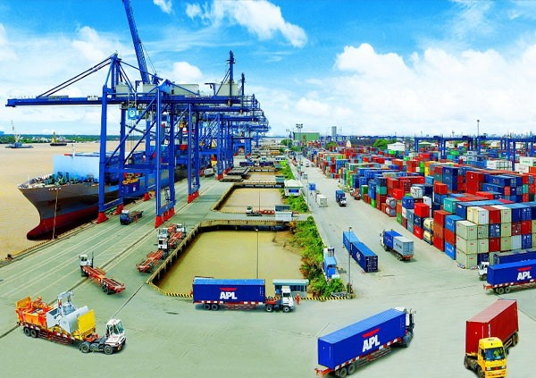
Cát Lái River Port in HCM City’s District 9. — VNS File Photo
A number of projects to expand road networks were completed, but did not ease traffic congestion, especially at the northwest gateway and the entry to Cát Lái Port, transport experts said.
Bùi Xuân Cường, director of the Department of Transport, said the city last year built 106km of roads and 21 bridges.
Võ Kim Cương, former deputy architect of HCM City, said that rapid urbanisation was one of the main causes behind the overloaded streets.
The inappropriate locations of ports have also caused pressure to existing road networks.
Cương said the city’s agencies should use the waterways to ease pressure on the city’s roads.
Hà Ngọc Trường, chairman of the HCM City Association of Bridges–Roads–Ports, said the city’s port network has not been fully developed due to the lack of connections between ports and city infrastructure.
Government agencies have focused on the development of land transport while waterway transport received meagre investments, said Trường.
Nguyễn Ngọc Tường, deputy chief of HCM City Traffic Safety Board, said the only way to reduce traffic congestions at roads and entries around ports is to improve waterway transport.
Phạm Sanh, a transportation expert from HCM City, said the waterway network was still not connected to roads, railroads, and the port network.
Morever, the clearance height of most bridges in HCM City is too low while canals are not frequently dredged and have low depth, making them inaccessible for large vessels.
“To develop water transport in HCM City, agencies must build a suitable plan for infrastructure development, especially for waterways connecting HCM City with the Mekong Delta region,” said Sanh.
HCM City agencies said that between 2018 and 2020 the city would mobilise investments from the private sector into water transport infrastructure.
For example, in 2018, upgrades of Bình Lợi Bridge in Bình Thạnh District will be completed, paving the way for waterway transport from Tây Ninh and Bình Dương provinces with ports in HCM City and Cái Mép ports in Bà Rịa – Vũng Tàu Province.
Dredging of canals will help link the Sài Gòn River with the Đồng Nai River.
Canals and rivers on Vàm Cỏ Đông, Chợ Đệm, Bến Lức, Rạch Dơi and Kinh will be dredged, while Ông Nhiêu, Rạch Đĩa and Rạch Dơi bridges will be upgraded to facilitate passenger and cargo transport from HCM City to Long An and Tây Ninh provinces.
Ports and piers along the Sài Gòn River will be moved to suburban areas, while wharves along Đồng Nai, Nhà Bè and Thị Vải rivers will be completed and upgraded.
Trường Thọ ICD (Inland Container Depot) will be relocated and upgraded.
A 6ha river port, to be built in a hi-tech park, will be able to take 1,000 tonne vessels.
City authorities will have plans to add new routes to connect Vàm Cỏ River with ports in Cái Mép – Thị Vải area, and to link Đồng Nai with Thị Vải rivers.
More ICDs will be built to help reduce the pressure on land transport facilities.
To meet the rising demand for passenger transport, the transport department has approved an 18ha passenger port with a 600m pier at Đèn Đỏ Cape in District 7, according to Phạm Công Bằng, head of the waterway transportation management division at the department.
The developer is completing the pre-feasibility study for the passenger port and will submit it to city agencies for approval, said Bằng.
Leave your comment on this story