

High tide water levels in Ho Chi Minh City are forecast to reach level 1 and cross 1.35 meters early September, the city Committee for Flood and Storm Prevention warned in an urgent dispatch to affected districts and relevant departments August 30.
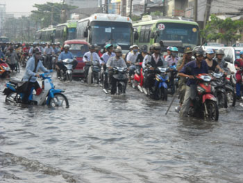 |
| High tide water levels to cross 1.35 meters in HCMC in early September |
High tide waters are already beginning to surge in the lower sections of the Sai Gon-Dong Nai River since August 30 and are expected to cross 1.35 meters along the Phu An Station and 1.33 meters along the Nha Be Station by August 31. High tide will peak from 4:30pm to 6:30pm, according to the Southern Regional Hydro Meteorological Center.
The Steering Committee for Flood and Storm Prevention has instructed districts to speed up measures to prevent flooding in highly prone areas of the city caused both by heavy rainfall and high tide. Adequate human resources should be available and appropriate equipment made ready for all worst case scenarios.
In related news, the National Hydro Meteorological Forecasting Center said that affects of Nanmadol Typhoon were felt in northern Vietnam on August 30, with weather conditions remaining hot and sultry. The storm has now moved northwards making a landfall along the coast of Fujian Province in China early this morning.
Average temperatures in the north hovered between 34 and 36 degrees Celsius. Some areas in Son La, Ha Giang, Cao Bang, Bac Kan and Quang Ninh Provinces experienced over 37 degrees Celsius.
All throughout August 31 muggy weather is forecast in the northern regions with average temperatures touching 36 degrees Celsius or even higher in some parts.
On the other hand, the southwesterly winds will cool temperatures in the southern and Central Highland provinces with scattered showers and thunderstorms in some parts.
Leave your comment on this story