

The most powerful Atlantic storm of 2010, Hurricane Igor, whipped up dangerous swells in the Caribbean on Tuesday as it barreled west-northwest in the direction of Bermuda.
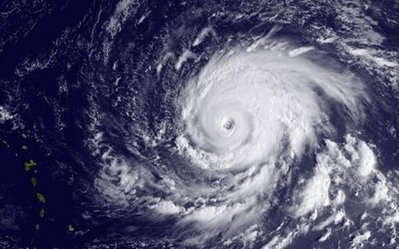 |
| This NOAA satellite image shows Hurricane Igor churning in the Atlantic Ocean. |
Igor, packing winds of 145 miles (230 kilometers) per hour is a category four hurricane, the second highest notch on the five-point Saffir-Simpson scale, and forecasters warned it was "getting stronger."
As the powerful storm churned through the Atlantic, the National Hurricane Center said tropical storm Karl had formed off the coast of Mexico\'s Yucatan peninsula.
Though still comparatively weak, the system threatened to dump more rain on Mexico, which is struggling with flooding in southeastern states including Veracruz and Oaxaca.
Almost one million people were affected by flooding this month alone which left 25 dead. The rains, which began in July, are set to worsen as the season continues to almost the end of the year.
More than one third of the Gulf Coast state of Veracruz has been hit by flooding which affected some 500,000 people, according to governor Fidel Herrera.
Igor is not expected to make landfall for days. Forecasters say the storm could reach Bermuda by Sunday, but caution it is too early to know if it will be a direct hit or how strong it will be five days from now.
"Exact impacts of Hurricane Igor at the end of the week are still difficult to gauge," the Bermuda Weather Service said.
"Much more detail on Igor will be covered in the next few days, as it likely becomes a potential threat to the island."
At 2100 GMT, Igor\'s eye was located some 655 miles (1,055 kilometers) east of the northern Leeward Islands and it was heading west-northwestward at eight miles (13 kilometers) per hour, US experts said.
Swells generated by the storm were due to begin affecting the archipelago later Tuesday before reaching Puerto Rico and the Virgin Islands late Tuesday and Wednesday.
"These swells are likely to cause life-threatening surf and rip current conditions," the Miami-based National Hurricane Center said.
Although the storm\'s strength was expected to fluctuate in the coming days, "Igor is expected to remain a very powerful hurricane through Thursday," it added.
Of more immediate threat to land was tropical storm Karl, which the NHC said could bring coastal flooding and up to eight inches of rain to Mexico and parts of Belize and northern Guatemala.
"A storm surge is expected to produce some coastal flooding near and to the north of where the center makes landfall," the center said. "The surge will be accompanied by large and damaging waves."
"Karl is expected to produce total rain accumulations of three to five inches over the Yucatan peninsula, Belize and northern Guatemala, with isolated maximum amounts of eight inches," the center added.
A third weather system, Hurricane Julia, continued to strengthen, with high winds increasing to 85 miles (140 kilometers) per hour, making it a category one storm as it tracked slowly west-northwest.
"Little change in strength is forecast during tonight or Wednesday, following by slow weakening by Thursday," the NHC said.
Last week, powerful Tropical Storm Hermine slammed into far northeastern Mexico and then barreled into US territory, sparking flash floods on both sides of the border.
Leave your comment on this story