Localities urged to closely watch Storm Vongfong for active preventive measures


Localities have been urged to keep a close watch on the development of Storm Vongfong for active preventive measures.
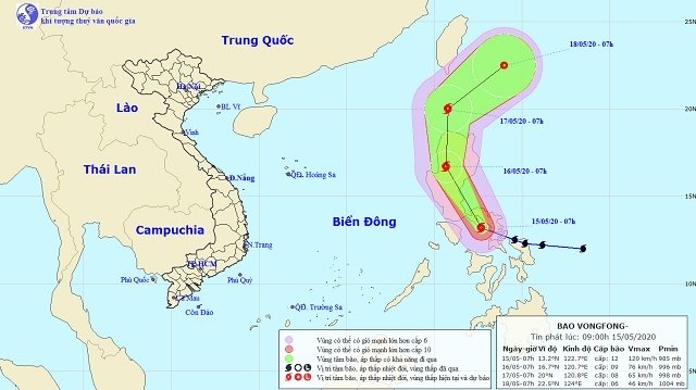
According to the National Centre for Hydro-Meteorological Forecasting (NCHMF), at 7 am on May 15, the position of the storm was in the central region of the Philippines, with the strongest winds blowing at 100-135 kph.
It is forecasted that in the next 24 hours, the storm will move in the North-western direction, traveling at a speed of 15-20 kph. By 7 am on May 16, the location of the storm is forecast to be on the west of Luzon Island (Philippines), packing strongest winds of 60-90 kph.
Over the next 24 to 48 hours, the typhoon would move northward, traveling about 15km every hour. By 7 am on May 17, the location of the storm will be about 150km to the north of Luzon, with wind speeds dropping to 60-75 kph.
Over the next 48 to 72 hours, the storm will move in a north-northeast direction, traveling 15-20 km every hour and weakening into a tropical depression.
The Steering Committee proposed that the local Steering Committees for Disaster Prevention and Search and Rescue to urgently support local people to overcome the consequences of natural disasters in recent weeks, while closely monitoring forecasts on disasters to inform local authorities and people to take proactive measures to prevent flash floods, landslides, heavy rains, hails, cyclones, and strong winds in a timely manner.
Meanwhile, the current heat wave is expected to extend in all regions across the nation from today, with the highest temperatures reaching 38C and over, according to the national weather service.
In the North, the highest temperature is forecasted to range from 33-36C, while the figure for the North-western and Central regions ranges from 35-38C at the highest. The time with temperatures of over 35C may last from 11-16 hours per day.
The Central Highlands and Southern provinces continue to suffer from hot weather with the highest temperature ranging from 35-37C.
The heat wave in the central provinces is likely to last until May 21, while the Central Highlands and the South may see its end tomorrow.
Today’s temperature in Hanoi is expected at 35-36C at the highest. From May 17, the heat wave will decline in the capital city.
Experts have warned of a high risk of fire and explosion in residential areas due to increased demand for electricity, as well as high risk of forest fires in the central provinces and the northern uplands. In addition, the heat can cause dehydration, exhaustion and heat stroke due to prolonged exposure to high temperatures.
The projected path of Storm Vongfong. (Photo: NCHMF)
In a dispatch sent to coastal provinces and cities from Quang Ninh to Kien Giang on May 14, the Standing Office of the Central Steering Committee for Disaster Prevention and Control recommended that the local authorities take measures to ensure the safety of ships operating on the sea.
According to the National Centre for Hydro-Meteorological Forecasting (NCHMF), at 7 am on May 15, the position of the storm was in the central region of the Philippines, with the strongest winds blowing at 100-135 kph.
It is forecasted that in the next 24 hours, the storm will move in the North-western direction, traveling at a speed of 15-20 kph. By 7 am on May 16, the location of the storm is forecast to be on the west of Luzon Island (Philippines), packing strongest winds of 60-90 kph.
Over the next 24 to 48 hours, the typhoon would move northward, traveling about 15km every hour. By 7 am on May 17, the location of the storm will be about 150km to the north of Luzon, with wind speeds dropping to 60-75 kph.
Over the next 48 to 72 hours, the storm will move in a north-northeast direction, traveling 15-20 km every hour and weakening into a tropical depression.
The Steering Committee proposed that the local Steering Committees for Disaster Prevention and Search and Rescue to urgently support local people to overcome the consequences of natural disasters in recent weeks, while closely monitoring forecasts on disasters to inform local authorities and people to take proactive measures to prevent flash floods, landslides, heavy rains, hails, cyclones, and strong winds in a timely manner.
Meanwhile, the current heat wave is expected to extend in all regions across the nation from today, with the highest temperatures reaching 38C and over, according to the national weather service.
In the North, the highest temperature is forecasted to range from 33-36C, while the figure for the North-western and Central regions ranges from 35-38C at the highest. The time with temperatures of over 35C may last from 11-16 hours per day.
The Central Highlands and Southern provinces continue to suffer from hot weather with the highest temperature ranging from 35-37C.
The heat wave in the central provinces is likely to last until May 21, while the Central Highlands and the South may see its end tomorrow.
Today’s temperature in Hanoi is expected at 35-36C at the highest. From May 17, the heat wave will decline in the capital city.
Experts have warned of a high risk of fire and explosion in residential areas due to increased demand for electricity, as well as high risk of forest fires in the central provinces and the northern uplands. In addition, the heat can cause dehydration, exhaustion and heat stroke due to prolonged exposure to high temperatures.
Leave your comment on this story